Haneya Routing Optimization
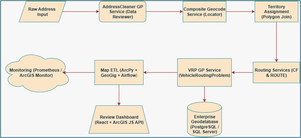
Haneya routing platform relies on separate Spectrum and esri tools, leading to redundant licensing costs, manual workflows, and performance bottlenecks at scale. We propose a unified ArcGIS-centric pipeline, automated via Apache Airflow and backed by an enterprise Geodatabase, that consolidates address cleansing, postal-grade validation, geocoding, map maintenance, routing, and multi-vehicle optimization into one end-to-end solution.
By leveraging existing ArcGIS Server services, including Data Reviewer for rule-based address validation, Composite Locator for postal-grade geocoding, and GeoGig for version-controlled map updates, PCF can fully replace Spectrum’s address cleansing, standardization, and validation functions within the Esri ecosystem.
By subscribing to ArcGIS Data Reviewer, it can be configured with custom rules (rcs) to detect formatting issues, missing components, and delivery point inconsistencies, closely replicating DPV-equivalent checks. The Composite Locator supports both U.S. (CASS-ready) and Canadian (SERP-compliant) formats when paired with licensed datasets, enabling precise geocoding and match scoring. Combined with ArcGIS’s routing and VRP capabilities, this Esri-only pipeline can process current volume of 250,000 to 300,000 subscriber addresses per day and can scale beyond 300,000 subscriber addresses per day in the future. This solution also generates optimized delivery routes for up to 250,000 stops, and maintain 99.9% availability, all while eliminating the need for Spectrum licensing. This solution not only delivers immediate cost savings, but also improves data integrity, ensures compliance with USPS and Canada Post standards, and enables full exception handling through a React-based operational dashboard.
We recommend moving forward with a three-phase rollout: (1) audit inventory of licenses and procure Canada Post reference data, (2) build and test the Airflow-driven GP service pipeline, and (3) onboard operations with training and hypercare support. This approach will give PCF a scalable, automated routing platform that lowers costs, increases productivity, and positions the business for future growth.
Business Benefits:
-
- Cost Reduction: Eliminates redundant Spectrum licensing and desktop workflows by centralizing all geospatial processes within ArcGIS. We propose saving a minimum of $250,000 by eliminating Spectrum over a 5-year period based on number of subscribers’ addresses validation using Spectrum.
-
- Efficiency & Accuracy: Automates current manual pipeline, enforces CASS/SERP compliance certifications for U.S. and Canadian addresses, and delivers rooftop-level geocoding where data permits. Decrease man hours spent on pipeline maintenance up to 40%.
-
- Risk Mitigation: Ensures postal-grade validation, maintains an authoritative, versioned map repository, and provides full audit trails for compliance and governance. As a result, up to 90% penalties can be eliminated.
-
- Agility & Control: Modular components with clear APIs allow future enhancements (e.g., hybrid geocoding, advanced clustering) with minimal disruption and highly scalable for future growth.
NEWSROOM

Benefits of Using Cybersecurity Risk Management Software
Every business is at security risk. They store private files, customer details, payment records, and work data on computers and in online systems. One small safety gap can invite big trouble and break customer trust very fast. Many companies now seek smart tools that protect sensitive data and keep online systems safe from malicious attacks. […]

How CRM Software Turns Visitors into Potential Customers
Every business wants happy customers. Many people visit websites every day, but many leave without buying anything. A smart CRM system helps businesses learn what people like and what they need. It helps teams answer fast and build trust with each customer. That is why many companies now use Harnis best CRM software for business […]

Enhance Your Business Operational Efficiency with Top ERP Solutions
In today’s highly competitive world, every organization needs ultimate systems that can help improve productivity, manage business operations, and make the right decisions. That’s why most organizations prefer to choose ERP solutions. Such tools are beneficial for businesses of all sizes. Such solutions can help you integrate main processes into a single platform. By investing […]

Transforming Business Operations with Supply Chain Analytics, AI & RPA Solutions, and SAP Certified Gold Partner Expertise
It is always a priority for companies to identify ways to improve their efficiency while simultaneously reducing their costs or expenses. With the complexity and layers of supply chains involved, keeping track of all the processes becomes difficult. In such situations, the concept of Supply Chain Analytics proves its worth. The idea is to use […]

What Is The Process Of Using AI And RPA Technologies Via SAP Certified Gold Partners To Improve Business Processes?
There are several challenges that companies face when trying to grow their businesses quickly and effectively; the largest of these challenges is often related to their traditional methods of performing a variety of business tasks. When you engage with a SAP Certified Gold Partner, you can take advantage of the combined capabilities of AI and […]
FOLLOW US
TALK TO OUR EXPERT
Partners